 "GeoGuide for emergency" provides geographic information related to emergency
To provide public with more ways to obtain the emergency information of Macao, Cartography and Cadastre Bureau, under the support of Unitary Police Service and Meteorological and Geophysics Bureau, has launched the “GeoGuide for emergency” mobile map App, which allows public to obtain important information such as the areas may be affected during different “Storm Surge” warning levels, the location of each Emergency Refuge Centre and the Emergency Hotline of Macao via mobile phone.
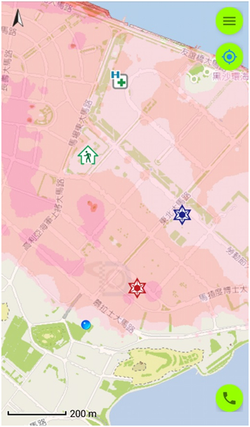
“GeoGuide for emergency” has built-in important geographic information such as areas may be affected during different “Storm Surge”, Emergency Refuge Centre, Meeting Place / Place to Stay for Emergency Evacuation, Hospital, Health Center, Public Security Unit, Fire Services Unit and Customs Unit, as well as has attached various types of hedging and disaster prevention guidelines. The public only needs to activate the satellite positioning function of the mobile phone to see if the current location is within the expected range of the “Storm Surge”, and learn about the location information of the nearby Emergency Refuge Centre and Place to Stay for Emergency Evacuation.
Once the network is connected, when Meteorological and Geophysics Bureau issues a “Storm Surge” warning, the application will display information such as the immediate warning level and the latest weather conditions. The application also provides offline viewing even if the network is disconnected, so that the public can still browse the urgent geographic information such as the areas may be affected during different “Storm Surge” via mobile phone.
“GeoGuide for emergency” is a project to coordinate with the development in emergency management system of Macao Special Administrative Region Government byCartography and Cadastre Bureau. It provides technical support for disaster prevention and mitigation through scientific and technological means, and assists the public in response to emergency via the application of geographic technology. “GeoGuide for emergency” (1st edition) is available in Traditional Chinese, Simplified Chinese, Portuguese and English, which can be downloaded for free by searching “GeoGuide for emergency” either in App store or Google Play, or by scanning the QR Code below. For details, please visit Cartography and Cadastre Bureau website