

 eTyphoonImg
The probabilities of issuing severe weather warning signals
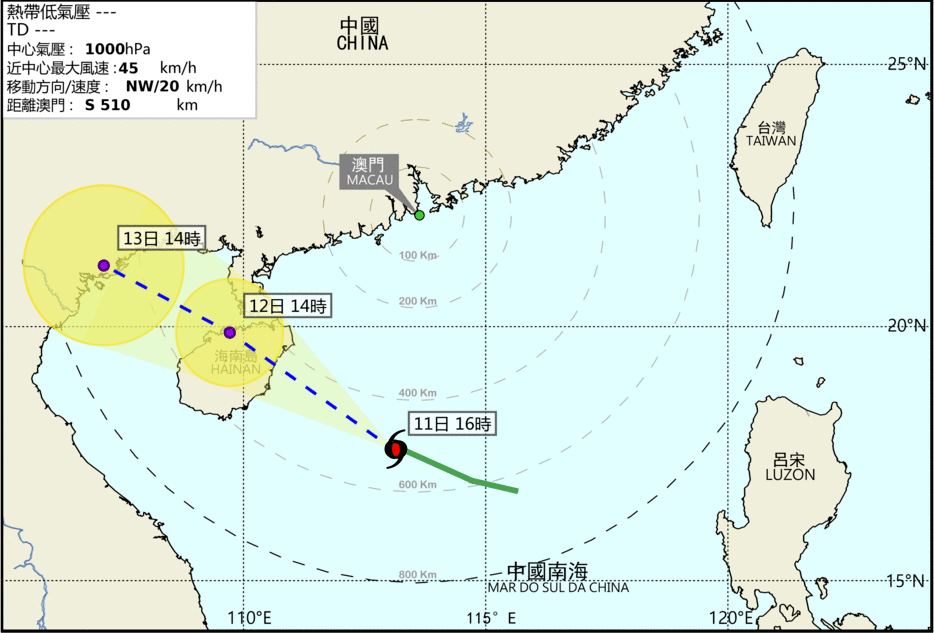
Update Time: 2021-06-11 16:30
| Signals | Forecast Period | Probability |
| Typhoon Signal No.1 | In effect | |
| Typhoon Signal No.3 | Between tonight and early morning tomorrow | Medium |
| Typhoon Signal No.8 | Low | |
| "blue" Storm Surge Warning | In effect | |
| "yellow" Storm Surge Warning | Low | |
The low pressure over the South China Sea has intensified into a tropical depression, which will come closest to Macao between tonight and tomorrow about 500km southwest of Macao. It will generally move towards Hainan Island. Under the influence of its circulation, the wind in Macao will increase significantly from tonight to tomorrow, with winds reaching level 6 and with showers occasionally. At the same time, under the combined effects of the astronomical tide and strong winds, the area in the inner harbor may be flooded tomorrow morning. The flooding height is predicted to be below 0.5 meters. The public are advised to pay attention to the latest storm news and take preventive measures.
Remarks: The probabilities of issuing severe weather warning signals for the next one or two days are provided in the table. Public can learn the possibility of being affected by the tropical cyclone over the specific period of time in Macao so that necessary precautions can be well prepared earlier. Please keep notice of our latest information.