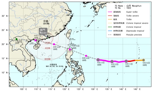
 Track of Super Typhoon “Mangkhut”
The Super Typhoon “Mangkhut” is now over the western North Pacific. It is well developed with a large gale circle. The maximum wind speed near its center has reached 240km/h. “Mangkhut” is forecasted to enter within 800 km of Macao on 15th morning and Typhoon Signal No.1 will be issued at the same time. Since “Mangkhut” will approach the coast of Guangdong and pose considerable threat to Macao and the Pearl River Delta, Typhoon Signal No.3 is expected to be issued on 15th night. As the latest forecast track of “Mangkhut” has adjusted to the north slightly, “Mangkhut” will cause serious impact on Macao when it comes closest to Macao on 16th. Frequent squalls and heavy showers are expected and there will also be serious flooding, around 1.0 to 2.5m above road level in low-lying areas due to storm surge.
If you have outdoor activities on 15th and on 16th, please make appropriate arrangements as soon as possible. Public are advised to take safety precautions against gale, heavy rainfall and storm surge, as well as pay attention to the latest information on "Mangkhut".
Possible warning signals to be issued due to the impact on “Mangkhut”
|
Signals |
Forecast Period |
Probability |
|
Typhoon Signal No.1 |
Morning on 15th |
High |
|
Typhoon Signal No.3 |
Night on 15th |
High |
|
Typhoon Signal No.8 |
Early morning to morning on 16th |
High |
|
“Orange” storm surge warning |
Sep 15 (Time period of flooding: Noon to evening on 16th) |
Relatively low |
|
“Red” storm surge warning |
Relatively high |
Remarks: The probabilities of issuing severe weather warning signals for next one or two days are provided in the table. Public can learn the possibility of being affected by the tropical cyclone over the specific period of time in Macao so that necessary precautions can be well prepared earlier. Please keep notice our latest information.
Possible impact by Super Typhoon “Mangkhut” on Macao
|
Impact on |
Period |
Forecast |
|
Temperature |
Sep 15 |
≥ 36℃ |
|
Air quality |
Bad |
|
|
Wind Force |
Sep 15 evening - 16 |
Wind Force Scale 8 – 12 (63 – 118 up km/h) |
|
Storm Surge |
Sep 16 noon - evening |
1.0 – 2.5m (Water level above road level of Porto Interior) |
|
Rainfall |
Sep 15 -17 |
150 – 250 mm |


