 eTyphoonImg
The probabilities of issuing severe weather warning signals
Update Time: 2021-08-03 20:00
| Signals | Forecast Period | Probability |
| Typhoon Signal No.3 | In effect | |
| Typhoon Signal No.8 | Low | |
| "blue" Storm Surge Warning | Low | |
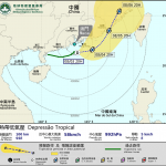
The tropical depression south of the Pearl River Estuary moving slowly in the past several hours. It is forecasted that the tropical depression will stay within 150km radius of Macau in the next 12 hours, and it will generally move towards the sea area east of the Pearl River Estuary. Affected by the circulation of the tropical depression, there will be occasional heavy showers and thunderstorms in Macau, with winds occasionally reaching level 6 with gusts. Therefore, the Tropical Cyclone Warning signal No.3 will remain in effect tonight, and the probability of issuing higher signals is low. The public are advised to pay close attention to the change in weather and the latest storm news.
On the other hand, the possibility of flooding caused by storm surge is low since the astronomical tide level is low around these days. However, the public should still pay attention to the possibility of flooding caused by heavy rains.
Remarks: The probabilities of issuing severe weather warning signals for the next one or two days are provided in the table. Public can learn the possibility of being affected by the tropical cyclone over the specific period of time in Macao so that necessary precautions can be well prepared earlier. Please keep notice of our latest information.


