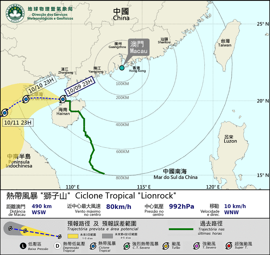
 eTyphoonImg
Possible warning signals to be issued due to the impact on "Lionrock"
Update Time: 2021-10-09 23:05
| Signals | Forecast Period | Probability |
| Typhoon Signal No.8 | In effect | |
| "blue" Storm Surge Warning | In effect | |
Since “Lionrock” gradually moves away from Macao and the combined effect of "Lionrock" and the northeast monsoon is also diminishing, the wind in Macao will gradually weaken. SMG will consider changing the Tropical Cyclone Warning Signal to No.3 between 2am and 4am on the 10th depending on the situation. However, the coastal area of Guangdong will still be continuously affected by the outer rain bands related to “Lionrock” during daytime on the 10th, and there will be occasional heavy showers and thunderstorms in Macao, with winds occasionally reaching level 6-7 with gusts. The public are advised to be careful and take preventive measures.
At the same time, currently there is flooding in the Inner Harbour area due to storm surge. The inundation level will decrease in the next few hours.
On the other hand, the tropical storm “Kompasu” which is located east of the Philippines is forecasted to move across the Luzon Strait into the northern part of the South China Sea in midweek next week. SMG will closely monitor the latest situation. The public are advised to pay attention to the latest storm news.
Remarks: The probabilities of issuing severe weather warning signals for the next one or two days are provided in the table. Public can learn the possibility of being affected by the tropical cyclone over the specific period of time in Macao so that necessary precautions can be well prepared earlier. Please keep notice of our latest information.


