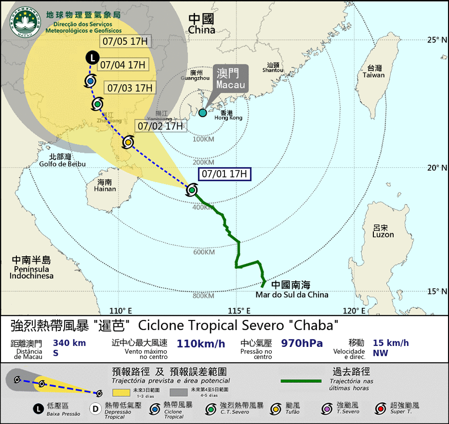
 eTyphoonImg
Possible warning signals to be issued due to the impact on "Chaba"
Update Time: 2022-07-01 17:55
| Signals | Forecast Period | Probability |
| Typhoon Signal No.3 | In effect | |
| Typhoon Signal No.8 | 01/07 20:00 to 23:00 | High |
| "blue" Storm Surge Warning | In effect | |
| "yellow" Storm Surge Warning | 01/07 Nighttime | Medium to relatively high |
Severe tropical storm “Chaba” is expected to move northwest and towards the western coast of Guangdong. It will move closest to Macao between 01/07 20:00 to 23:00.
As “Chaba” is expected to develop into a typhoon, the wind force in Macao may reach the lower limit of the wind force of typhoon signal No. 8. SMG will consider issuing typhoon signal No. 8 between 01/07 20:00 to 23:00 depending on the development of “Chaba” and changes in the local wind.
Under the influence of the outer circulation of “Chaba”, its related rainband will bring unsettled weather to Macao. The winds will intensify, occasional heavy showers and thunderstorms are still expected in Macao with heavy showers and reaching level 6 -7 winds, with occasional 8 and gusty winds.
Meanwhile, as it is during the high phase of the astronomical tide today and tomorrow, slight flooding has occurred over Inner Harbor Area this morning.
Under the combined influence of the storm surge and persistent rain, flooding around 0.5m is expected to occur on the 2nd of July, between 8a.m. to 2 p.m.. The Blue Storm Surge Warning is in effect. At the same time, as “Chaba” continues to intensify, the possibility of yellow storm surge cannot be ruled out.
SMG will closely monitor its development. The public is advised to take precautions in advance and pay attention to the latest news.
Remarks: The probabilities of issuing severe weather warning signals for the next one or two days are provided in the table. Public can learn the possibility of being affected by the tropical cyclone over the specific period of time in Macao so that necessary precautions can be well prepared earlier. Please keep notice of our latest information.


